|
|
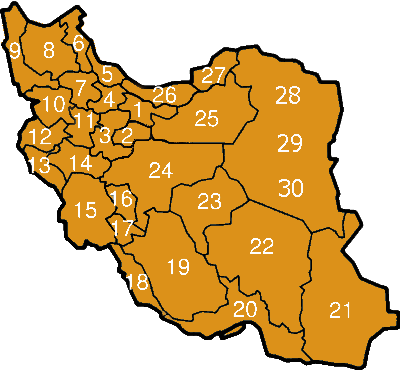
Iran Map
-
The province of Tehran
has nearly 12,000,000 inhabitants and is
Iran's most densely populated region. Its area is around 18,637 square
kilometers. The city of Tehran is the center of the province and the
capital of the country, it is the central district of the province.
Other districts are: Shemiranat, Islam Shahr, the city of Ray, Karaj,
Jajrood, Lar, and Rood Shoor. The province gained importance when
Tehran was claimed the capital by the Ghajar in 1778. Today Tehran
ranks in the top 20 metropolitans of the world.
-
Qom
is one of the 30
provinces of Iran. It is in the north of the country, and its center is
Qom. It was formed from part of Tehran province in 1995.
-
Markazi is one
of the 30 provinces of Iran. It is in the west of the country, and its
center is Arak. The present boundaries of the province date to the
1980s, when the province was split into the current Markazi and the
Tehran province, with portions being annexed to Esfahan, Semnan province
and Zanjan.
-
Qazvin may refer to:
-
Qazvin province
-
Qazvin (city)
-
Guilan is a
province in Iran, during antique time known as part of Hyrcania, with a
population of approximately 2 million and an area of 14,700 sq. km. It
lies just west of the province of Mazandaran, along the Caspian Sea. The
center of the province is the city of Rasht.
The main harbor is Bandar-e
Anzali (previously Bandar-e Pahlavi).
-
Ardabil
is one of the
30 provinces of Iran. It is in the north-west of the country, bordering
the Republic of Azerbaijan and the provinces of East Azarbaijan, Zanjan,
and Gilan. Its center is Ardabil. It used to be part of East Azarbaijan
province, and was made a separate province in 1993. It's famous natural
region is Sabalan mountains. The majority of Ardebil province's
population is composed of Azerbaijanis.
-
Zanjan
is one of the
30 provinces of Iran. It is in the north-west of the country, and its
center is Zanjan. Zanjan province has an area of 36,400 km² and a
largely rural population of 1.7 million. It is famous for its seedless
grapes. The majority of Zanjan province's inhabitants are Azerbaijanis.
-
East Azarbaijan
is one of the 30 provinces of Iran. It is in the north-west of the
country, bordering Armenia and the Republic of Azerbaijan, and the
provinces of Ardabil, West Azarbaijan, and Zanjan. Its center is Tabriz.
-
West Azarbaijan
is one of the 30 provinces of Iran. Population: 2,000,000 (1990). Area:
37,500 sq. km.
It should not be confused
with the west part of the Republic of Azerbaijan.
Religion
Most follow Shiite Islam;
however, there are numerous Christian minorities such as the Assyrians
which have historically lived on the west shore of Urmieh lake as well
as Armenians which are scattered throughout the province. Notably the
city of Maku in northern West Azarbaijan was the only city in Iran
(before World War II) where Christians comprised the majority.
-
Kordestan
is one of
the 30 provinces of Iran, not be confused with the greater geographical
area of Kurdistan. It is in the west of the country, bordering Iraq.
This province is one of the most mountainous provinces of Iran and has a
generally cold climate.
The center of this province
is the city of Sanandaj. Other major cities of this province are Marivan,
Baneh, Saqqez, Qorveh, Bijar and Sardasht. Sorani-Kurdish is the spoken
language of the majority of the people in this province which is a
North-Western Iranian language related to Persian.
-
Hamadan
is one of the
30 provinces of Iran. Its center is Hamadan city.
-
Kermanshah
is one of
the 30 provinces of Iran. It is in the west of the country, bordering
Iraq. Its center is Kermanshah. Between 1979 and the 1990s, the province
was known as Bakhtaran.
-
Ilam
is one of the 30
provinces of Iran. It is in the south-west of the country, bordering
Iraq. Its center is Ilam.
-
Lorestan
or Luristan
comprises a province and an historic territory of western
Iran south of the Zagros Mountains.
In the wider sense (as its
name implies), "Luristan" refers to the land of the Lurs, namely
that part of western Persia bounded by Iraq on the west and extending
for about 400 miles on a northwest to southeast axis from Kermanshah to
Fars.
|
-
Khuzestan
is
one of the 30 provinces of Iran. It is in the south-west of the country,
bordering Iraq and Kuwait. Its center is Ahvaz.
-
Chahar Mahaal
and Bakhtiari
is one of the 30 provinces of Iran. It is in the south
of the country. Its center is Shehre-Kurd.
-
Kohkiluyeh and
Buyer Ahmad
is one of the 30 provinces of Iran. It is in the
south-west of the country, and its center is Yasuj.
-
Bushehr
is
one of the 30 provinces of Iran. It is in the south of the country, with
a long coastline onto the Persian Gulf. Its center is Bandar-e-Bushehr.
-
Fars
is one
of the 30 provinces of Iran. It is in the south of the country. Its
center is Shiraz, Iran.
Roughly, Fars is
the original homeland of the Persian people. The native name of the
Persian language is Farsi or Parsi. Persia and Persian both derive from
the Hellenized form of the root word Pars. Fars is arabicized version of
Pars. The Old Persian word was Parsa.
-
Hormozgan
is
one of the 30 provinces of Iran. It is in the south of the country,
facing Oman. Its center is Bandar Abbas.
-
Sistan and
Baluchistan
is one of the 30 provinces of Iran. It is in the
south-east of the country, bordering Pakistan and Afghanistan, and its
center is Zahedan.
The province is the
second largest in Iran with the area of 181,600 sq km and a population
of 2.1 million.
In the south and
west of Sistan and Baluchistan the people are mostly Balochi and speak
the Baluchi language.
The capital of the
province is Zahedan with a population of 420,000 inhabitants.
-
Kerman
is
one of the 30 provinces of Iran. It is in the south-east of the country.
Its center is Kerman. The province of Kerman is the third largest in
Iran, 180,000 km². The population of the province is about 2 million.
Most of the province is largely steppe or sandy desert, although there
are some oases where dates, oranges (said to be the best in Iran) and
pistachios are cultivated. The province is dependent on ghanats
(underground water channels) for its irrigation. In the central parts
there is a mountain region with Mt. Hezar being the highest peak, 4465
meters from the sea.
-
Yazd
is one
of the 30 provinces of Iran. It is in the center of the country, and its
center is Yazd.
-
Esfahan
(sometimes rendered as Isfahan) is one of the 30 provinces of
Iran. It is a central province, and has its center at Esfahan.
General
information about the province
-
Surface: 107027
square km
-
Population in the
year 2000: 3,923,255
-
Population of the
Isfahan city: 2,540,000
-
Number of
townships: 18
-
Number of
counties: 38
-
Number of cities:
67
-
Number of rural
districts (Dehestan): 117
-
Number of
inhabited cities and villages: 2470
-
Literacy rate:
%87
-
Semnan
is
one of the 30 provinces of Iran. It is in the north of the country, and
its center is Semnan.
-
Mazandaran
is a province in northern Iran, bordering the Caspian Sea in the north.
Mazandaran or Mazenderan was a part of the Persian province of Hyrcania.
The name is from
Old Persian "mahs Indra" (Great/Big Indra, a Vedic god).
History
Mazandaran changed
hands often early in its history (Russia...) and was incorporated into
the Persian Empire by Shah Abbas I in 1596. It was formerly a part of
the greater province of Taparestan
or Tabaristan. Two
famous 9th-century Persian scholars from Tabaristan, were both commonly
called "al-Tabari" (simply "from Tabaristan")
-
Golestan
is
one of the 30 provinces of Iran. It is in the north-east of the country.
Its center is Gorgan. It was split off from the province of Mazandaran
in 1997.
28,29,30. Khorasan
(also spelled Khurasan
and Khorassan and now it has been
devided into 3 provinces: North Khurasan, Razavi Khurasan and South
Khurasan ) located in eastern and northeastern Iran. The
name Khorasan is Persian and is made up of parts which mean "where the
sun arrives from". The name was given to the eastern province of Persia
during the Sassanid empire.
Currently Mashhad
is the center of Razavi Khurasan, Birjand the center of South Khurasan
and Bojnourd the center of North
Khurasan.
click to enlarge
|
A law has been passed in the Parliament
The Majlis, which means parliament or assembly in the Arabic language, was the
lower house of the Iranian Legislature from 1906 to 1979. After the Islamic
Revolution, when the Iranian Legislature became unicameral, the Majlis became
the main legislative body.
It was first created by a clause in the 1906 Iranian Constitution and soon
gained power under the rule
(May 18, 2004) and the Council of Guardians (May 29, 2004) to further
divide the province of Khorasan into three new provinces: North Khorasan,
South Khorasan, and Razavi Khorasan.
Provinces are governed from a local center, mostly the largest local city.
Provincial government is headed up by a governor , who is installed by the
Minister of Interior.
|